« April 2007 |
Main
| June 2007 »
May 30, 2007
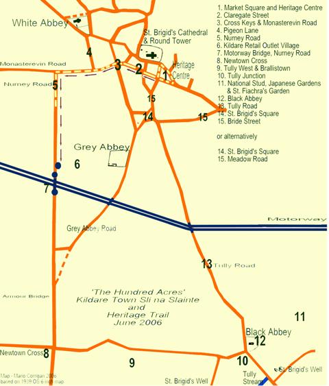
The Hundred Acres - Self Guided Walking Tour of Kildare Town and Environs
This Walking Tour is intended as a self-guided tour - The Hundred Acres Booklet can be purchased in Kildare Town in Kildare Town Heritage Centre or in Kildare Retail Outlet Village - it is fully illustrated with alternative routes for the regular visitor and walker. It is reproduced here textually for people to download. The route is approximately 4.3 km.
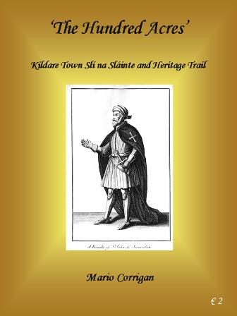
‘The Hundred Acres’
Kildare
Town Slí na Sláinte and Heritage Trail
by
Mario Corrigan
Kildare Town was an important monastic site and was situated on the ancient roadway/routeway, the Bealach Muighe Dala or Slighe Dhála Meic Umhóir (Slí Dála), the Road of the Assemblies or Road of Dála son of Umhóir, one of the five legendary routes that sprang up magically on the night of the birth of Conn of the 100 Battles (an ancestor of St. Brigid) and traversed Ireland, converging on Tara. It is fitting that the term Slí is once more associated with Kildare and that the joy of walking can be rediscovered in the unique Heritage Town of Kildare, which was originally called Drumcree meaning in the Irish language, Droim Criaig – the Ridge of Clay.
Kildare, or in Irish, ‘Cill Dara,’ meaning ‘Church of the Oak’ was named after the church founded here under an oak tree by St. Brigid in the later end of the 5th century. In light of its association with the Patroness of Ireland, as Brigid became known, it was to develop into what some were to describe as a great metropolitan or ‘monastic city,’ a place where visitors and pilgrims were welcome and plentiful. But this guide is for everybody, whether it is the first time visitor, the returning pilgrim or the resident interested in finding out a little more about where they live. Mostly it is to encourage us all to take time to walk around the town and spend some time there, to allow ourselves time to relax or get fit, to understand a little more about the heritage of the town or to simply find a good place for a cup of coffee, a pint or place to shop – or to try them all.
For many the guide will provide an accompaniment to their regular walking routes, in the spirit of the slí na sláinte routes that have become so popular nationwide. It is hoped that it is an activity to be shared and enjoyed by all and that people always engage in walking to suit their own personal needs and that they recognise their limits. Find a partner or partners who can share the experience, not force you into competition or force an injury. Always warm up, and try and adapt and change your route or method to keep the interest going (there are variations on the route at the end). Dress properly and at all times be conscious that others share the road and - BE SAFE.
[The title ‘The Hundred Acres,’ came out of a conversation with Stephen Talbot who said that the route now enjoyed by walkers was always known locally as ‘the hundred acres.’ I did a bit of checking and it is a local name for most of Tully West townland, i.e. mostly the land between
Nurney Road / Grey Abbey Road and Tully Road which forms a natural triangle between St. Brigid’s Square,
Newtown Cross Roads and Tully junction. In researching an article on the Black Abbey (the ruins of the church can still be seen near the National Stud) I found mention in inquisitions taken at the dissolution of the monasteries that the immediate land attached to the Knights Hospitallers Preceptory, the villa of Tully, amounted to some 160 acres of arable land – 60 acres of demesne land beside the Preceptory and another 100 acres of land which probably represented large portions of what came to be known as Tully West and Tully East. Could this term, ‘the hundred acres,’ have survived in popular memory from the thirteenth century since most of these lands were granted to the Hospitallers prior to 1212 A.D.?]
]
‘The Hundred Acres’
Kildare Town Slí na Sláinte and Heritage Trail
by
Mario Corrigan
Beginning: Market Square – KildareTown Heritage Centre and St. Brigid’s Cathedral and Round Tower
1. MARKET SQUARE KILDARE – A market was held in Kildare Town from ‘time whereof memory runs not’ but the weekly Thursday market that exists today was established by Statute of Parliament in 1458 and confirmed in the Kildare Town Charter of 1515. There is a mention of a Market Place in Deeds going back to 1726 but the first reference to Market Square in available maps dates to 1798. The Square was the commercial hub of Kildare town and remains the centre of the town in close proximity to St. Brigid’s Cathedral and Round Tower.
St. Brigid – Mary of the Gael – is the patroness of Ireland. Her feast day, St. Brigid’s Day, is on the 1st of February (she died around 523 or 524 AD) and is celebrated each year in the town under the auspices of the Brigidine nuns during the Festival of Féile Bríde. Brigid is forever associated with Kildare Town and the Curragh was known as St. Brigid’s Pasture’s or Pasturage. According to legend it was granted to St. Brigid by the King of Leinster in return for reducing the size of his ears. Having agreed to settle for a portion of land that her cloak would cover, Brigid threw down her cloak and it magically continued to spread until it encompassed the whole plain. The Curragh is synonymous with horse racing and is home to many classics in particular the Budweiser Irish Derby. Kildare Town celebrates this association annually with the Kildare Derby Festival.
St. Brigid’s Cathedral – This marks the original site of the Church of St. Brigid which was established under the shade of a large Oak Tree and from which Kildare or Cill Dara (Church of the Oak) gets its name. The stone cathedral is probably of medieval/Norman construction and was built/rebuilt by Ralph de Bristol, Bishop of Kildare, c. 1223 A.D. The modern Cathedral was almost completely rebuilt in the late 19th century and re-opened in 1896. Within the grounds of the Cathedral are the Round Tower (c. 12th century) of Kildare and the remains of St. Brigid’s Fire-House where an ‘in-extinguishable fire’ was kept until the early 13th century. This fire now forms the basis of a permanent feature on the Market Square in front of the Heritage Centre, unveiled by the President of Ireland, Mary McAleese, on St. Brigid’s Day 2006. The Cathedral also houses early Christian stone slabs and historic stone effigys, such as that preserved by the Kildare Archaeological Society of Walter Wellesley, Bishop of Kildare which was removed from Great Connell (near Newbridge) for safe keeping.
Near the traffic lights and pedestrian crossing on the south side of the Square a Monument of St. Brigid was unveiled in 1973 in memory of the 350 who died in the Gibbet Rath Massacre on 29 May 1798. It was sculpted by James McKenna.
In the centre of the Market Square is the Market House now converted into a modern Heritage and Tourist Centre. An audio-visual presentation explores the rich history and heritage of Kildare Town, and there is tourist information and a gift/souvenir shop on-hand for visitors. The original Market House probably dates to the 17th century or earlier but the building has undergone many changes. The Heritage Centre was restored as part of the successful campaign to have Kildare designated a Heritage Town and was officially opened in September 2001 by Minister, Charlie McCreevy.
On the south or Main Street side of the Market House is a plaque commemorating the centenary of the 1903 Gordon Bennett Cup, the precursor to the modern Grand Prix Motor Races. Run over a figure-of-8 circuit incorporating the counties of Kildare, Laois and Carlow, it was won by the Belgian, Camille Jenatzy, known as the ‘Red Devil,’ because of his wild driving. The 1903 race was the first time international teams were identified by the colour of their cars. The Race is commemorated every year since 2003 by the local Vintage and Classic Car Club. Kildare Town was an important ‘Control’ point on the route. On the eastern side near the roof, depth gauges are still visible, whereby the level of water could be measured when the upper storey housed the water tank, designed to store water pumped from St. John’s Well at Tully. On the northern (Nugent St.) side a plaque commemorates the completion of the Kildare Waterworks in 1886.
Many of the buildings around the Market Square can be traced back to the early 20th and mid-late 19th century but the streetscape has remained surprisingly unchanged from John Rocque’s map of 1757.
On the eastern side of the Heritage Centre an eighteenth century well has been uncovered (2003) and restored to become a permanent architectural feature of the Square. The Market Square was the site of a water pump/fountain from an early stage and remained the principal source of water supply for the town until water was pumped to the town in the 1950’s. There is a Celtic Cross Monument, unveiled in 1935, which was erected to the memory of the 7 Republicans who were executed in December 1922 at the Curragh Military Camp during the Irish Civil War. Across from this monument a lane leads to the ‘people’s park,’ where the last remaining tower (originally there were 4 towers) of the castle of Kildare can be seen. The first castle was probably built by Strongbow but developed by William Marshall, Earl of Pembroke, c. 1185. The people’s park was the location of Kildare Lodge, the property of Thomas Connolly of Castletown which was for a short time, home to the military leader of the United Irishmen, Lord Edward Fitzgerald and his beautiful French wife, Lady Pamela. A bust of Lord Edward by the artist Annette McCormack was unveiled on the Market Square, near the Republican Monument, in 2003 on the 205th anniversary of his death.
The first part of the Journey takes the walker from the Heritage Centre and the Market Square to Claregate Street. It is probably best to cross the pedestrian crossing, turn right and cross Bride St., i.e. with the Market Square behind you to walk on the left hand side of Claregate Street. This will necessitate crossing Bang-up Lane at the Eurospar Shopping Centre and though a pedestrian way is marked on the road, walkers should take care to look in all directions and over their shoulder as vehicles can turn left and right onto this lane.
2. CLAREGATE STREET– Also referred to in surveys and maps as Middle St. (1674) and West St. (1843) – Claregate St. or Sráid Gheata an Chléir was named after Clare Gate (West Gate in 1801) – one of the three gates to the walled town of Kildare. The gate was demolished sometime before 1757.
The town suffered dreadfully during the 1798 Rebellion and it is said that there were 85 widows in this street alone after the Gibbet Rath Massacre on the Curragh. In the mid-19th century it housed the Police Station and Post Office and remains one of the main commercial streets of the town. Some of the well-known families of Kildare Town such as Heffernans, Doyles, Connollys, Malones, O’Neills, Hennessey’s, Mahons and McCormacks had businesses (some still do) on this street. Paddy McCormack was a well-known local poet and songwriter; John T. Heffernan was a prominent member of the Land League and member of the first County Council in 1899. Claregate Street is intersected by Heffernan’s Lane (north/right side) and Bang up Lane (south/left side) and was widened at the west end, where Eurospar now stands, in the 1960’s to allow for the increase in vehicular traffic and as part of the urban renewal programme that saw the removal of many artisan cottages.
3. CROSS KEYS – the walker should again approach this junction with care - look in all directions as vehicles can turn left and right onto Claemore Road and cross from White Abbey Road.
The junction of Claregate St., Monasterevin Rd., Claemore Road (Academy St.), and White Abbey Rd., at the west end of Claregate St. is known as Cross Keys (Cros Chae – St. Cae’s Cross), the address applied to all the houses immediately lining the crossroads. One of the water pumps that supplied the inhabitants of the town with water stood at Cross Keys around 1900. The Co-operative Stores of the 1920’s and Ryans Seed Shop of the 1930’s which succeeded it, operated from the shop frontage visible at the corner of Claregate Street and White Abbey Road. The Harp Bar on White Abbey Road was a famous stopping off point for the internationally renowned Irish traditional/folk group ‘The Dubliners,’ in their early touring days. Opposite the Harp was the E.S.B office and Kearney Cycles. 1936 saw the opening of the Wallpaper factory, now occupied by Mahon’s Wholesalers (through the junction on the left/south side), which brought much needed employment to the town.
Continuing West through the Cross Keys junction we come to Monasterevin Road, so named on maps from 1853 onwards but also known as Duneany Lane (1674) and Turnpike Rd. (1757-1817). This was the main exit/approach to the town with the arrival of the Turnpike Road. The establishment of the Town as a Post town on the mail coach road to and from Dublin re-vitalised the town as did the arrival of the Turf Club c.1760 and the subsequent further development of the Curragh Racecourse.
4. PIGEON OR PIDGEON (1847) LANE - leads to the Carmelite Church (White Abbey - founded c.1290; modern church opened in 1889) and St. Brigid’s Park (opened in 1936) and for many years marked the outermost limit of expansion of the Town of Kildare. By hiding out in one of the fields which border the Lane (subsequently owned by the Wallpaper Factory) a brother of a former local priest, Fr. Philip Rouse (d. 1779), escaped from the military during the 1798 rebellion.
5. NURNEY ROAD (LEFT TURN) marks the turn from Kildare towards Newtown Cross Roads past Abbey Villas (almost opposite Pigeon Lane on the left hand side – on 1939 OS Map) and before Fraochbawn. Hawk Hill farm can be seen in the distance on the north/right hand side of the road.
On the northern side of the junction the Kildare Tidy Towns Committee have had the embankment landscaped with the insertion of an evergreen St. Brigid’s Cross. The junction is close to the area where the mail coach was stopped on the night of 23rd May 1798 – the signal for the United Irishmen that the Rising had begun. A young officer, Lt. William Gifford, was taken from the coach and murdered by the rebels, an event which was to have tragic consequences for the town. A relative of his was part of the relieving military force which massacred the rebels at the Gibbet Rath some days later.
On the right is Modus Link (opened in 1995 but the company is in Kildare Town since 1st Oct. 1984) and in a field just past the factory is the Sovereign’s Well (the town had been incorporated under James II and the Corporation of Kildare had a Sovereign, portreeves, burgesses, freemen etc.). The well was accessible from the town via Love Lane (closed in 1908). On the left as you progress down Nurney Road towards the 1st Roundabout is the new Retail Outlet Village.
6. KILDARE RETAIL OUTLET VILLAGE – care should be taken as traffic to and from the Village navigates this Roundabout.
Kildare Village is home to over 53 international and domestic luxury and fashion brands selling last season's collections at discount prices. The Village contains 850 free car-parking spaces, a children's playground, two restaurant cafes and a Tourist Information Centre to promote the Village and the region. Three features have been added to the Village which serve to recognise the importance of the heritage of the Town and surrounding area – two bronze Irish Wolfhounds, Bran and Sceolang, the Hounds of Fionn Mac Cumhaill, legendary hero and leader of the Fianna, who had their home on the nearby Hill of Allen; an Oak Tree, symbolising the establishment by St. Brigid of her Church at Kildare in the later 5th century; a monument to the Friar’s Well, acknowledging the contribution of the religious Orders to the development of the Medieval Town of Kildare.
Behind this village is the Grey Abbey, a Franciscan foundation which dates to around 1260. It was named after the colour of the habits worn by the Franciscan monks. All that remains are the ruins of the Abbey Church but the foundations of the cloister etc. to the south of the Abbey, in ‘Butler’s Field,’ are still visible in the undulating field surface. The eastern-most portion of the field was also once a part of the abbey graveyard before the present graveyard was enclosed. One of the earliest manuscripts written in the English language in Ireland which dates to around 1320 is attributed to ‘Friar Michael of Kildare’ and portions of the Annals of the Four Masters were transcribed at Grey Abbey by Brother Michael Cleirigh. The Abbey was granted to David Sutton in 1543 after the dissolution of the Monasteries. It is the burial place of at least four Earls of Kildare. A monument (1948) was erected at Grey Abbey to commemorate seven men executed in 1922 on the Curragh during the Irish Civil War and who were re-interred there in 1924. Grey Abbey House, now a Veterinary Clinic, was at one time the home of the Graham family who owned the once famous Graham’s Bakery suppliers of ‘Graham’s Bread,’ commonly known as ‘Kildare Bread.’
1st ROUNDABOUT AT BRIDGE – care should be taken to look right as vehicles on the roundabout will take the slip road to the motorway towards Dublin.
7. BRIDGE OVER MOTORWAY – Kildare By-Pass was opened on the 8th Dec. 2003 by Transport Minister Seamus Brennan
2nd ROUNDABOUT AT BRIDGE – care should be taken to look left as vehicles on the roundabout will enter the roundabout from the slip road from the motorway from Dublin.
From the bridge, looking to the left (south-east), you can see the white walls of Minoru Yard, which is part of the Irish National Stud, known locally simply as ‘The Stud,’ or ‘National Stud.’. The motorway and 2nd roundabout cut through an area known locally as ‘Graham’s Bottoms,’ on the town side of Silliot Hill which can be clearly seen in the distance to the south-west/right. This formed part of a gruelling county championship cross-country circuit in the 1950’s and 1960’s which was won by prominent local runners such as Anthony Fitzsimons, Denis Horgan and John Mackey. The Round Towers Gaelic Football Club and Kildare Rugby XV also played some of their early matches at Graham’s Bottoms.
To the right as you come off the Roundabout is a rise called Teahouse Hill. On the left a junction with Grey Abbey Road leading back to Kildare
Care should be taken to look in all directions for vehicles intending to access Kildare via Grey Abbey Road.
Grey Abbey Road offers an alternative route for walkers to and from the town, particularly from St. Brigid’s Square at the Church. The route of the Old Grey Abbey Road is still visible in the fields past the junction. Roughly where the old route and the modern road merge is Armour Bridge which protected the route of an old stream, the Brathogue or Bratogue, the path of which led from Brallistown Commons and Tully West to Grey Abbey townland and Loughlion.
Because the footpath is not continuous beyond the junction the walker must actually cross the main Nurney Road at this point. Great care should be taken to look right, left and right again before crossing the road but it is safer to cross after the junction.
On the immediate right is a well-known local garden Centre owned by the Guilfoyle family. This is the point, known locally as Armour Well, where the water gathered near Armour Bridge and formed a favourite spot for kids fishing for pinkeens (tiny fish that were usually netted and brought home with pride in ‘jam jars’ – glass jars that were often empty jam or condiment jars). The wooden fencing on the left is part of the network of National Stud field systems. The last field just before Newtown Cross, on the left, was once the home of Moortown Football Club. The walker has now entered the civil parish of Tully as distinct from that of Kildare.
NEWTOWN CROSS – This necessitates crossing the road to return to the east/left side. Wheelchair and buggy access is provided but it is right at the junction and extreme care should be taken to check for traffic in all directions before attempting to cross.
8. NEWTOWN CROSS – TULLY WEST – The junction of the Nurney Road with the road to Tully and the road to Moortown, Rathmuck and Duneany is traditionally known as Newtown Cross. To the right the Road lead in ancient times to the Church at Duneany which was part of the Knights Hospitallers Commandery at Tully. It also leads to Silliot Hill which was a centre of quarrying and fox-hunting.
Turning left/east towards Tully, the road is bounded on the left and right (north and south) by the townland of Tully West. Much of the land belongs to the Irish National Stud. There are splendid uninhibited views of the Town of Kildare to be seen on the left while walking towards Tully. Almost immediately on the right (to the south) is the Bull Performance Testing Station which is the responsibility of the Dept. of Food and Agriculture and run by the Irish Cattle Breeding Federation. Just past the Testing Station a sign points across the road to ‘Murphy’s Yard (on the left/north side of the road) which is part of the National Stud – a plaque on the front of the building reads River Lodge which possibly was a name given to it by the Boland family. Officially however it is known as Murphy’s Yard and unlike most of the other Stud Yards which are named after famous horses it was named after the Murphy family, of whom Tommy and his son Michael worked for years at the Stud as grooms.
Continuing towards Tully brings the walker to one of the most famous historic sites in Kildare – St. Brigid’s Well.
9. TULLY WEST and BRALLISTOWN COMMONS – South (to the right) of the road leading to Tully are the townlands of Tully West and Brallistown. Nearby is an area of land within the townland of Brallistown incorporating two smaller townlands, Brallistown Commons and Brallistown Little.
BRALLISTOWN COMMONS - or as it is known locally, ‘the Greallachs’ meaning wet or marshy ground, has long been associated with St. Brigid. According to tradition Brigid kept her cow there, prayed there, and made butter beside the stream. There is a lane (signposted) leading from the road to the site of St. Brigid’s Well, a place of pilgrimage and veneration. There are many traditions associated with the well such as the story of St. Brigid’s “Shoes,” or as they are also called her “Cows.” These are two granite stones, 32 inches by 12 inches, hollowed out so that the stream water passes through them. According to the flow of water through each of them at certain times of the year, it is said that one cow is “going dry” or is dry, and the other is “a new-milch cow,” or “in full milk.” Owing to the cleaning of the larger stream and the stream from the well, the position of the Shoes or Cows has varied. In reality they are probably medieval water-shoot stones from Tully Church or Castle. Pilgrims have always prayed on the Mound beside the stream and it remains a place of pilgrimage particularly during the festival of St. Brigid, Féile Bríde, which is held in February each year. The well and the shrines were renovated by the people of Tully in the autumn of 1952 and officially blessed on, St. Brigid’s Day, 1953, the year of the An Tóstal celebrations.
In the field on the corner to the right/south near the Tully junction is a building known as The Granary which was once used to store grain to feed the horses. The old stables were once used as an isolation yard to keep sick horses away from the main Stud.
10. TULLY - The junction at Tully (from Tulach meaning ‘rising ground’) is dominated by the ruins of the Black Abbey, the adjoining Graveyard and the Irish National Stud. It is also the site of another (some say the original) St. Brigid’s Well (Ordnance Survey Map 1837). This holy well was walled in by the Office of Public works in the 1950’s. Tradition has it that as well as being a place of veneration and pilgrimage it was a source of water for the inhabitants of Kildare Town prior to the water being piped from St. John’s Well. A plaque on the wall reads ‘A brigid Naomta (A bhrigid Naofa), Muire na nGaedeal, Duid Orainn. 1953 – St. Brigid, Mary of the Gael, Pray for Us, 1953.
The well is slightly off the main Slí near the junction which leads to the entrance to the Japanese Gardens and it is easily accessible to pedestrians but necessitates crossing the main road - south at the junction of Tully Road (opposite Black Abbey) and again opposite the restored wall above Tully Stream to actually visit the well so extreme care should be taken at all times. Regular work routines necessitate vehicular traffic from the Stud and locals regularly use these roads. The Irish National Stud and the Japanese Gardens are host to an enormous number of visitors particularly during the summer months and are well worth a visit should time permit.
11. THE IRISH NATIONAL STUD – JAPANESE GARDENS AND ST. FIACHRA’S GARDEN – while the Stud naturally dominates the landscape at Tully, the main entrance for tourists and visitors is actually around the corner from St. Brigid’s Well, through the extensive car-park and not through Gannon’s Gate (black gate) on the Tully Road. It is well signposted from the Tully junction.
THE IRISH NATIONAL STUD - In 1900 Tully was purchased by Colonel Hall-Walker, later Lord Wavertree as a racing stable. Shortly after he converted it to a Stud (Tully Stud) for the breeding and rearing of thoroughbred race horses and acquired a priceless collection of foundation mares. Many winners of Irish and English classics were bred at Tully. Lord Wavertree offered the Stud to the government in 1915 and the Stud and thoroughbreds became the property of the state under the management of Sir Henry Greer. It proved to be a highly successful venture and in 20 years the yearlings alone had brought in some £250,000. This success was jeopardised when, in 1943, the stock was taken to England. From 1922 to 1943 the English Government had paid an agreed sum in lieu of rent to the Irish Government. On January 1st, 1944, the Irish Government took possession of Tully and until bloodstock could be purchased it was farmed and grazed with cattle.
The Irish National Stud Company was formed and the National Stud Act passed in the Dáil in August, 1945. The breeding of high-class thoroughbreds was to be the sole business of the National Stud at Tully which was to make available to small Irish breeders sires of the best class at reasonable fees, and so improve the thoroughbred strain in Ireland. Sires were also to stand at other centres through the country. A limited number of high-class brood mares were to be purchased to maintain an annual supply of stock for future breeding. The first purchase made by the Directors was the famous Royal Charger who proved to be a highly successful sire. One of the most famous sires, Tulyar, was purchased for £250,000, on the 5th February 1952, an astronomical sum at that time but it failed to fulfil its destiny and was soon after sold to the U.S.A.
As well as being a world renowned centre for breeding thoroughbred race horses the National Stud has become world famous for its training courses. It is also home to the ‘Irish Horse Museum,’ which was refurbished in 2006 – where the skeleton of the world famous ARKLE is on display, and where, through the quality of the exhibition, the ‘Sport of Kings,’ comes to life. Lavish musicals were staged in the grounds of the Irish National Stud in the 1970’s and it was at one time home to Cill Dara Rugby Club.
JAPANESE GARDENS AND ST. FIACHRA’S GARDEN – One of the most famous tourist attractions in Ireland, the Japanese Gardens are contained within the grounds of the National Stud. They were planned by Col. Hall-Walker and built (1906-1910) by Tasa Eida and his son Minoru (he had at least one other son – Kaiji) from Japan at a cost of £38,000. With the help of local labourers, rock and stone from Silliot Hill and Wicklow were used to great effect to create the gardens, with Irish and English trees and shrubs added to the obvious Japanese elements to create a truly unique experience. The gardens were planned to symbolise the Life of Man from the Cradle to the Grave – the journey of the human soul through all its experiences from birth through to the afterlife.
To celebrate the 2nd millennium (2000 A.D.) the Irish National Stud created St. Fiachra’s Garden. St Fiachra is the patron saint of gardeners and this garden has 4 acres of woodland and lakeside walks designed to represent the monastic movement in 6th and 7th century Ireland.
Returning to the junction at Tully
12. BLACK ABBEY - there is pedestrian access through a gate in the fence but care should be taken to close this gate after you enter and particularly after you exit. Likewise care should be take to close the gate to the graveyard once you have finished your visit.
Tully is the site of the Black Abbey, a commandery of the Knights Hospitallers or Knights of the Order of St. John of Jerusalem. They took their name from a hospital dedicated to St. John the Baptist, which had been founded in the holy city to assist pilgrims. They, like the Templars, were soldier monks and when the Templar order was abolished in 1312 most of their possessions in Ireland were given to the Hospitallers. The Hospitallers adopted the rule of St. Augustine and wore a black habit in the commandery – hence the name Black Abbey. The original grant of land at Tully was confirmed by the Pope in 1212 A.D. As well as workers who farmed the land and provided hospitality there were chaplains, Knights on horseback and foot-soldiers, Esquires, a butler, chamberlain and servants etc. Their members were identifiable by a black cloak with a white cross. The commandery held jurisdiction directly from the pope and held land in Southgreen, Duneany and Rathbride (which may have been originally a Templar foundation). There were churches at the two latter sites, the ruins still visible at Duneany, and also a commandery at Rathbride. There is a tradition that the Hospitallers bred horses at Tully and documentary evidence of a water-mill and mill-race. Some 400 yards north of the Abbey is St. John’s Well – another ancient place of pilgrimage for the inhabitants of and visitors to Kildare. It was for a time the main source of water supply for the town.
After the dissolution of the monasteries by Henry VIII the land passed to David Sutton. Later it became the property of the Sarsfield family and there is a local tradition that the great Jacobite General Patrick Sarsfield was born at Tully (there is a tradition in Newbridge that he was born at Roseberry Castle). By 1700 the land had passed for a short time to the Medlicott family who, for the next 200 years, had long associations with the town but whose principal residence became Dunmurry. The family vault is in the grounds of St. Brigid’s Cathedral and when this was full the Medlicotts were buried at Dunmurry. There are graves of some well-known Kildare families such as Moores and Bergins in the graveyard at Tully which is well-maintained by the National Stud.
Returning to the Slí na Sláinte the road from Tully to Kildare is known as Tully Road. On the left-hand-side is the townland of Tully West and on the right hand side is Tully East mostly part of the Irish National Stud.
13. TULLY ROAD – The large black gate next to the Black Abbey graveyard is known as Gannon’s Gate – named after John Gannon a groom at the Stud for many years. He was the son of the famous Kildare Gaelic footballer, Bill ‘Squires’ Gannon. On the right, in the Stud grounds, is a long unit that resembles stable boxing. The Irish National Flag, the Tri-colour, can be seen flying in the Stud grounds. Next is a small thatched cottage with a thatched porch which was once the home of John and Katie Owens and would have stood close to the road before the road was re-modelled to accommodate the by-pass. John worked for many years in the Stud. There are a couple of private residences and an unusually long cottage which was originally the home of the Conway family, most of whom emigrated to the U.K. There is a sign for the Downalong Arts and Crafts Centre.
LARGE WHITE ENTRANCE – a beautiful vista of Kildare Town dominated by the spire of the Carmelite Church. The entrance on the left leads to another part of the Stud, Minoru Yard. Minoru was the son of Tassa Eida but it was also the name given to of one of the most famous horses associated with the Stud. A lane near the motorway bridge on the right hand side of the road leads to the sewerage works and pumping station. Bill ‘Squires’ Gannon a member of the local Round Towers Gaelic Football Club who captained Co. Kildare to victory in the 1928 All-Ireland Gaelic Football Final worked at the waterworks and sewerage farm. The 1928 Final was the first time teams played for the famous Sam Maguire Trophy but sadly it was (as of July 2006) the last time Co. Kildare were victorious in an All-Ireland Football Final. Bill Gannon was heavily involved for many years in the community and was a member of St. Brigid’s C.Y.M.S. Pipe Band. He used to practice his pipes while walking up and down the lane.
The original works were constructed in 1883 but were replaced in 1900. For a time the responsibility of the Co. Board of Health it is now the responsibility of Kildare Co. Council.
BRIDGE OVER MOTORWAY – KILDARE BY-PASS – the bridge offers great views of the town dominated by the Carmelite spire, Eurospar, the Round Tower and Cathedral, the R.C. Church, St. Brigid’s Square and the Curragh Lodge Hotel (the former Co. Infirmary). To the left can be seen Grey Abbey House, the ruin of Grey Abbey Chapel and Kildare Retail Outlet Village.
The by-pass was opened 8th Dec. 2003 by Transport Minister Seamus Brennan – sometime before the opening many Kildare residents walked part of the new route in aid of charity. A specially commissioned sculpture on the Kildare By-Pass, entitled ‘The Race of the Black Pig’ (in deference to the ancient route across the Curragh), embodies the symbol of Kildare, St. Brigid’s Cross.
To the right is the property of Oak Church Nurseries (marked for deliveries). This rise of ground after the bridge is the area known as ‘Cunnaberry Hill,’ from ‘Coney’ meaning rabbit and berry or burrow signifying an area where rabbits were plentiful and probably a well-known poacher’s paradise dating back to medieval times. Next to this is an area known locally as Boland’s Field which was a place where local kids played football. Amongst the buildings on the right is Oak Church Nurseries which has an unusual courtyard effect in front. Behind the houses on the right hand side of the road the land was originally called Gleab or Glebe land as it belonged to the Church.
On the left is the Kare Centre - a house named Valetta which has a plaque ‘Kildare 1900’ and clearly pointed gables. It was occupied by Dr. McCarthy from the 1940’s to the 1960’s. There was a dispensary at or near to this site since around 1905. Next door today is the modern Health Centre operated by the South Western Area Health Board. On the corner as you enter St. Brigid’s Square is a small stone cottage simply called ‘The Cottage.’ This was in the possession of the Hopkins family for at least 3 generations, best known for their development of a hackney (taxi) service in the Town. The cottage was at one time leased out to a well-known cobbler (maker and repairer of shoes), Tom Byrne, who, it is said , with his wife, raised 6 or 7 children in that cottage. Many of their grand-children are still resident in the Town today.
14. ST. BRIGID’S SQUARE – Where Tully Road enters the Town (this marks the boundary of Tully and Kildare civil parishes – i.e. Meadow Road to Grey Abbey Road). Unnamed in 1757 this was originally the Fair Green (and was also called at different stages Pound Green). A fair was authorised to be held on St. Brigid’s Day in 1458 and 2 additional fairs from 1763. Between 1734 and 1881 between 2 and 9 fairs were held per year in Kildare but by 1894 they were held monthly. In reality no fairs (except for pig fairs) were held in St. Brigid’s Square after the establishment of the Fair Green north of Shraud (in Elm Park) in 1869. By 1939 the maps show this area was called St. Brigid’s Square – after St. Brigid’s R.C. Church. Around the early 1920’s parts of the Square were fenced in and planted but these were likewise removed and the area in front of the church is now a triangular parking area defined by the division of Bride Street into Tully Road and Grey Abbey road. The fencing was removed opposite the C.Y.M.S. Hall but some of the trees remain.
The Square is dominated by St. Brigid’s R.C. Church which was built in 1833 and opened by ‘the Liberator’ Daniel O’Connell who had famously and successfully campaigned for Catholic Emancipation. Tradition has it that he gave a gift of the first bell to the Church to mark the opening. The tower was added in 1851. Four saints statutes once adorned this tower but were taken down for safety reasons prior to 1926. The church was built by Fr. Patrick Brennan who also built St. Brigid’s Hall which in it’s lifetime was a school, community hall, infant school, and drama club HQ. - the site now occupied by the beautifully restored Parish Centre, Áras Bhríde. A plaque on the wall reads, THE ORIGINAL ST. JOSEPH’S ACADEMY OF THE DE LA SALLE BROTHERS WAS LOCATED IN THIS BUILDING FROM 1913 – 1938 ERECTED BY THE PAST PUPILS UNION SEPTEMBER 1993.
In 1871 a Mission Cross was erected between the entrance to the Church and the main gate – this was later removed and is now in St. Brigid’s Park. Fr. Brennan was also responsible for bringing the Presentation Sisters to Kildare in 1830 and for the building of the Convent.
The Square used to be the home of the Pound when fairs were carried on there and at one time it was the site of the electric power house. When this was no longer used it was acquired by the parish priest for the use of the community and opened as a C.Y.M.S. Hall. A new hall was built and opened on Sunday 2nd July 1950 and it continues to dominate the west side of St. Brigid’s Square. Opposite the Hall is a modern funeral home. At one stage this site was a temporary place of worship and around the 1920’s the site of one of the early cinemas in Kildare Town. The houses and shop units immediately opposite the Church on the left hand side of the Square may date back to the early 19th century.
15. BRIDE STREET - North of St. Brigid’s Square leads to Bride Street also known in its time as Bergan or Bergin Street and Chapel Street. On the east (right) side on the wall just past the Parish Centre, Áras Bhríde, is a plague to Fr. Benjamin Broughall, the Pilgrim Priest which reads – FATHER BROUGHALL PILGRIM PRIEST NEAR THIS ACCORDING TO TRADITION WAS BORN IN 1780 FATHER BENJAMIN J. BROUGHALL P.P. CRAICNAMANACH. PILGRIM TO ROME AND THE HOLY LAND. IN 1840 HE ENTERED THE MONASTERY OF MONTE CASINO AND DIED THERE IN 1850 WITH A GREAT REPUTATION FOR SANCTITY.
This devout and holy man was born in Kildare in 1780. He became parish priest of Graiguenamanagh in 1818 but became dangerously ill and resolved, when better, to make a pilgrimage to the Holy Land. This he began in 1822 travelling almost entirely on foot reaching the Holy Land in 1827 after bouts of illness. His return to Ireland was also plagued by bouts of illness and on more than one occasion it was expected he would not recover. He was back in Ireland briefly in 1838 but set out again in 1839 to live as a hermit in Italy. He was admitted to the Benedictine Monastery of Monte Cassino in 1840 and died there in 1850 in his seventy-first year, revered for his piety.
On the western (left) side of Bride Street, immediately opposite Áras Bhríde, is the Day Care Centre (on the site of the old St. Conleth’s Hall) for the care of the aged. Next to this is a block of three buildings, one of which (middle) is the Kildare Medical Centre and Well Woman Centre. Next to this block is the Monastery School – Scoil na Mainistreach De La Salle (inscribed on the gate pillar), which was built in 1884. A green flag flies proudly at the gate signifying the An Taisce and Kildare Co. Council environmental award won by the school and its students. A plaque on the south side of the building reads THIS TOWN HALL AND CHRISTIAN BROTHERS SCHOOL WERE ERECTED BY MICHAEL LEE ESQ. OF KILDARE. COUSIN OF HIS EMINENCE CARDINAL CULLEN. A. D. 1884. The Upper floor was the Town Hall (despite the absence of a town council or corporation) and residence of the De La Salle Brothers. The De La Salle Brothers ended their long association with the town in 2004 and their former residence is now home to The Immaculate Heart of Mary Sisters.
Next to it is the modern Kildare Credit Union where medieval stone work was uncovered during excavations in 1999 and was preserved by means of a transparent floor. Circular plaques on the south and eastern gables date the building to 2000. Just past the Credit Union is ‘Bangup Lane’ (Bangup was a colloquial term in the early 19th century for an Irish frieze or heavy woollen overcoat but there is no known meaning for the actual naming of this lane). The lane was at one time the home of Kildare Chilling Co. which was established there in 1941 – the new premises on the Dublin/Curragh Road was opened in 1967. The Lane now affords pedestrian access to the Eurospar shopping centre but operates as a one-way system for vehicular traffic which must exit on to Bride St., the entrance for traffic being from Claregate St.
THE END – MARKET SQUARE
1. MARKET SQUARE - Continuing up Bride Street the walker arrives once more at the Market Square, maybe to visit the Cathedral, Heritage Centre or various shops, pubs restaurants etc. and sample the hospitality of one of Ireland’s oldest historical towns – Kildare, the Heritage Town.
Alternative ending to the Slí na Sláinte.
From Tully Road – instead of St. Brigid’s Square and Bride Street – After ‘The Cottage’ cross the road with care, to the wall of St. Brigid’s Church and take the road on your right (to the east).
14. ST. BRIGID’S SQUARE –
The alternative route back to the Market Square means taking Meadow Road/Convent Road past the Presentation Convent.
15. MEADOW ROAD – In 1757 it was referred to as Boreena Clona Lane and later Boreena Cloonagh/Clonagh (little road of the meadow). It was subsequently called Chapel Street and Convent Road but was re-named Bóthar na Cluaine or Meadow Road by 1985. The Presentation Sisters have been in Kildare since 1830. Across the road behind the high wall was ‘The Nun’s Walk,’ where the Nun’s would take exercise away out of public view. Near to this was an area known as Sally’s Gardens which stretched down towards Blind Lane (also on maps as Blindwell Lane) .
Past the Convent the large imposing building on the left, Kilgowan Lodge, was the former Surgeon’s residence, built in 1866. The Curragh Lodge Hotel was the former Co. Infirmary which was opened in 1777 although a temporary Infirmary was established in Kildare since 1767. It had a chequered career and was closed finally in 1959, sold and converted to the ‘Derby House Hotel.’
This brings the walker to Dublin Street, turning left towards the Market Square (the street on the left was known as Hospital Street). Immediately across the road is the local Garda Station or Police Station. This was the site of a former Church of Ireland School, established in 1829. Past the Hotel, on the left hand side, there is a high wall around another old house, St. Rita’s. This was originally the nurses home but was purchased by John and Peggy Barry and turned into the first modern guest house in Kildare Town (there had been taverns, inns and hotels).
Continuing up the left hand side of the street, but looking across to the right hand side, there is a large 2 storey red-bricked building called Ivydene which may date back to the late 1700’s or early 1800’s. Next to it is the entrance to Beechgrove housing estate which takes its name from Beech Grove House on the Market Square side (west side) of the entrance to the estate. Beech Grove has undergone some changes but the original dwelling predates 1757. Next is the exit from the Silken Thomas car park and next is the Court House which dates to 1829.
On the left hand side of the street, across from Ivydene and the entrance to Beechgrove estate is the boundary wall (with an entrance) of the Presentation Convent. On this wall is a commemorative plaque to mark the establishment of the Turf Club of Ireland on this site from 1798-1908. It was formerly the site of the Curragh Coffee House, built in 1759. Next to this is the Post Office (c. 1908). Opposite the Silken Thomas at the entrance to the Market Square is Lislee House (set a little back from the road with a garden in front) which was built between 1757 and 1798. This brings the walker back to the Market Square and an alternative ending to the Slí na Sláinte. Other items of note – Abrakebabra occupies the site of the Old Garda Station; Graces pub was formerly the Leinster Arms Hotel and may correspond to The Garter Inn mentioned in 1763; The Bank of Ireland was formerly the Hibernian Bank, built c.1903; Boyles and Bolands are among some of the oldest businesses in the town; The House at the entrance to the People’s Park on the eastern side of the Square, occupied by the Conlan family is known as Virginia Lodge, built c. 1864.
KILDARE TOWN SLÍ NA SLÁINTE AND HERITAGE TRAIL
– MARKET SQUARE – CLAREGATE ST. – CROSS KEYS – MONASTEREVIN ROAD/PIGEON LANE – NURNEY ROAD – NEWTOWN CROSS – TULLY – TULLY ROAD - ST. BRIGID’S SQUARE – BRIDE ST. - MARKET SQUARE
THE ROUTE SHOULD BE VARIED AND CHANGED CONSTANTLY TO MAKE IT CHALLENGING, FUN AND TO KEEP THE INTEREST OF THE REGULAR WALKER OR VISITOR TO KILDARE TOWN.VARIATIONS ON THE ROUTE AND FUN CONCEPTS WILL BE AVAILABLE ON www.kildare.ie/greyabbey
Posted by mariocorrigan at 12:02 AM
May 26, 2007
Rare Books Fair, Craft Fair and Car Rally 3 June 07 Kildare Town
Local Studies, Genealogy and Archives
Kildare
County Library and Arts Service
in association with
Lyonshill Books & Cill Dara Old Vehicles Club
presents
THE 2007
COUNTY
KILDARE
RARE BOOKS FAIR
AND
GORDON BENNETT IRISH CLASSIC CAR RUN
KILDARE
TOWN 1 p.m. – 5 p.m.
SUNDAY 3 JUNE 2007
All welcome - No cover charge
RARE BOOKS FAIR -
KILDARE
TOWN HERITAGE CENTRE and
KILDARE
TOWN PARISH CENTRE
CRAFT FAIR - BOLAND’S YARD.
CLASSIC CAR RUN -
THOUSANDS AND THOUSANDS OF BOOKS, RARE, ANTIQUARIAN AND LOTS OF BARGAINS And FREE VALUATIONS !!!
History, local, national, literature, poetry, sport, fiction and ephemera.
Why not take the opportunity to visit
Kildare
Town – ST. BRIGID’S CATHEDRAL, THE
JAPANESE
GARDENS , KILDARE HERITAGE CENTRE and the fantastic
KILDARE
OUTLET
VILLAGE .
More info:- Mario Corrigan PH 087-9871046 (Tues to Sat) – Email:- localhistory@kildarecoco.ie
Eddie Murphy PH 087-2567908 Email:-lyonshillbooks@eircom.net
Details of the 2nd County Kildare Rare Books Fair Sun 3 June Kildare Town - also a Craft Fair and the Gordon Bennett Commemorative Rally - all free - all on the same day.
Posted by mariocorrigan at 02:47 PM
Cill Dara Historical Society Annual Outing 2007
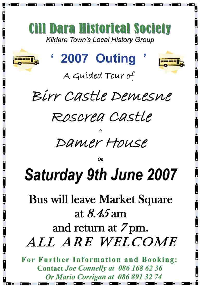
Details of the Cill Dara Historical Society Outing for Sat. 9 June 2007 to Birr and Roscrea - anybody interested should contact us straight away. If it is anything like last years then expect a great day out.
Posted by mariocorrigan at 01:54 PM
May 21, 2007
Death of Edward Medlicott of Dunmurry, 1872
The Leinster Express, Saturday, November 30, 1872, p.5
Births, Marriages, and Deaths.
Deaths.
Medlicott-On the 25th instant, at “Maison de Santa” Hospital, Dublin, after a short illness, Edward Richard, 1st Class Sub-Inspector and Inspector of Musketry to the R.I. Constabulary Depot, Phoenix Park, second son of the late Mr E. J. Medlicott, of Dunmurry, county Kildare, aged 40.
….
Same page, different column
..
THE LATE SUB-INSPECTOR MEDLICOTT, ROYAL IRISH CONSTABULARY. – The funeral of the late Sub-Inspector Medlicott, of the Royal Irish Constabulary, took place on Wednesday from the Maison de Sante, Charlemont-street, Dublin to Mount Jerome Cemetery, Harold’s Cross, where the prayers were read by the Rev. Mr Long. The cortege was attended by a large number of brother officers and sorrowing friends of the deceased. The chief mourner was Mr E. J. Medlicott, J.P., county Kildare. Almost all the non-commissioned officers and most of the men of the barracks, Phoenix Park, accompanied the remains to the grave, thus testifying the respect they bore for their late musketry instructor. In the carriages were the following officers of the service:- Colonel Hillier, D.I.G.; T. M. Brownrigg, A.I.G.; J. Duncan, A.I.G.; and Commandant of the Depot; W. Colomb, Adjutant; Dr. E. Le Clerc, T. W. Gloag, V.S.; T. M. Frith, Dr. Swan, V.S.; A. Reid, D. Smyth, T. Pelley, J. G. Webb, T. E. French, - Douglas, W. E. O’Shea, S. B. Rodger, B. A. Somerville, W. Law, H. H. Jones, J. M. O’Brien, A. E. S. Heard, A. J. M’Dermot, T. H. Warren, R. C. Carter, &c.
Posted by mariocorrigan at 09:54 PM
May 15, 2007
ANCIENT WELL, MARKET SQUARE, KILDARE TOWN
THE ANCIENT WELL ON THE MARKET SQUARE, KILDARE TOWN
by
STEPHEN TALBOT
The Well was uncovered firstly in June 1973 by the Council's road crew and I just happened to be on hand and took some colour slides. My now late father was also in attendance on that fine summer morning. Work was in progress at the time, refurbishing the market Square and the then Council overseer, who had discovered the Well in the first instance, received an instruction from KCC at St. Mary's to close in the Well immediately for safety reasons. No thought was given to it's historical significance. My father was most disappointed and asked me to try to do something to have it reopened.
Soon after, I commenced my campaign (which was to go on for 30 years) to have the Well uncovered and refurbished and stepped up the campaign again in the mid-late eighties.
It wasn't until May 2000 that I finally managed to arrange a meeting with County Architect, Brian Swan and after much discussion and correspondence an effort was made by GMB construction to locate the Well. We only had photographs to guide us and out of the blue, two more photos turned up. The late Marty Flemming had also taken pictures in 1973. However, on 25th Jan 2002, that effort failed as they were looking in the wrong area. No further efforts were made until the Autumn of 2003 when the Well was finally reopened and refurbished. It was excavated to a depth of 13 feet although it is originally some 80 feet in depth. Provision for lighting at the bottom was made and there are lights installed around the circumference at the top. The Cover is galvanised but it is hoped that with the passage of time a more suitable covering will be installed.
A plaque was made from polished granite was commissioned in 2006 which reads: Ancient Town Well.. This Well, in existence since 1757 was the town water supply until 1886. It was accidentally uncovered in 1973 and closed again for safety reasons as it was 25 metres in depth. It was rediscovered in 2003 and refurbished by Kildare County Council.
[additional note on the water supply of Kildare - From articles in the Leinster Leader (1882 and 1901- no mention of well in this later one Church of the Oak pp. 40 and 49) on the pumps and water supply and the dating of the waterworks in the Market Square to 1886 I think it could be argued that the well was closed in 1886 or certainly around 1886 when the water was pumped from Tully.
According to the Historic Towns Atlas the well on the Square was
1763 - draw well
1817 pump
1838 fountain
1847 - pump house
1872 pump
1873 no building
1882 pump
It says the pump was later removed. The Waterworks constructed 1882-6 and extended in 1897; water pumped from St. John's Well, Tully c. 1 km S.E. of Kildare to a tank in the roof of the market square (nearly sure the date-stone on the Nugent St. side says 1886 which would indicate the operation of the water works).
I would imagine that once the water works was in operation then the pump would have been removed and the well covered but an article from the Leinster Leader 1973 (Church of the Oak pp. 92-3) suggests the well may have been an emergency backup (at the very least) for the town in the early days of the 20th century - Mario Corrigan]
Stephen Talbot has to be commended on his efforts to preserve and record one of the ancient sources of water for the town and it should serve as a reminder to us all to be ever vigilant in terms of protecting and preserving the history and heritage of our local environment in so much as we can.
A note by Stephen Talbot on the discovery and re-discovery of the Ancient Well on the MArket Square of Kildare Town
Posted by mariocorrigan at 10:53 AM
Federation Annual Seminar
Kildare Federation of Local History Groups Annual Seminar
Historians from Carbury to Castledermot and everywhere in between will gather in Kilcullen on Saturday 26 May for the annual seminar of the Kildare Federation of Local History Groups.
With over a dozen affiliated groups throughout Kildare the Federation gives locals involved in the history movement a chance to share discoveries and knowledge. The programme begins at 10am in the Kilcullen Heritage Centre where an array of Co. Kildare topics will be presented followed by an open forum. In the afternoon the participants will travel to Clongowes Wood College for a guided tour of the hallowed college and its castle orgins. This is the eight annual seminar run by the Federation and the event will be opened by Mayor of Kildare, Cllr. Fionnuala Dukes.
Topics to be covered on the morning include the fascinating story of the Lock Hospital in Kildare by award winning historian Hugh Crawford; the old Naas Gaol by Brian Crowley and the story of Thomas Wentworth who commissioned Jigginstown Castle by writer and broadcaster Mae Leonard.
For more information and registration contact Federation Secretary Larry Breen on 045 897445.
A note from Liam Kenny on the forthcoming Kildare Fedaration of Local History Groups Annual Seminar an ideal opportunity for people to meet, learn and discuss the heritage and history of Kildare
Posted by mariocorrigan at 10:32 AM